Open topic with navigation
What's New in ARCHIBUS V. 22?
GIS Enhancements
ARCHIBUS V.22 includes the following enhancements for GIS;
Google and Esri Support
Geospatial intelligence is key for visualizing business data. GIS features can locate a wide range of activity -- on buildings, capital projects, work requests, reservations, moves, vacancies, leases -- within a common operating picture that gives you intuition and insight that you could not gain by reviewing the information alone.
In V.22, you can now use either Google or Esri map content or a mixture depending on which map layers and background content you prefer. Each provider offers a rich set of real-world context for your business information. For instance, Google provides locations of nearby businesses and features. Esri provides data such as satellite imagery, topography, and roads and sites, and you can license use of advanced data sets, such as demographic data.
Users of Google maps who generate a high-volume of queries (25,000 map loads per day) should review Google's licensing policy.
A new ARCHIBUS Standard Map control based on the Leaflet API delivers all of the standard map functions using either Esri or Google content. These functions include map display, map layer selection, asset location, marker click actions, single and multiple data source support.
The new universal map control supports a wide range of markers:
| Name
|
Description
|
Example
|
| Simple |
.Markers denoting location.
|

|
| Thematic |
.Markers themed in color by data category or bucketed data ranges.
|

|
| Graduated. |
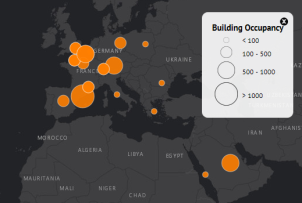
Markers graduated in size by data value or bucketed data ranges.
|

|
| Thematic-graduated |
Themed by data category and graduated by data value.
|

|
| Proportional |
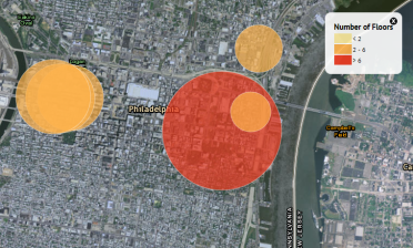
Proportional to real-world distance (as you might use to display an evacuation radius).
|

|
Map Types
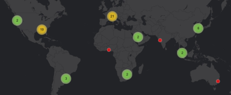
Clustered markers are fantastic for displaying a large number of locations. Clustered markers group locations together where there are a large number of markers in one area. When you zoom into that area, the clustered markers resolve into smaller clusters and then individual markers. Whether displaying buildings, room reservations, work orders, project locations, or sensor results, clustered markers can make quick sense of a large amount of information.
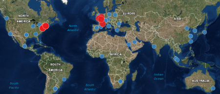
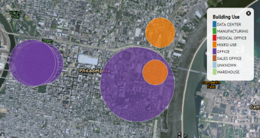
Maps with multiple data sources can show multiple types of information, such as buildings and properties, on the same map.
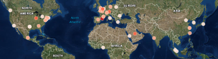
Thematic markers show data themed by category, such as buildings themed by building use.
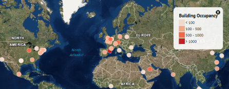
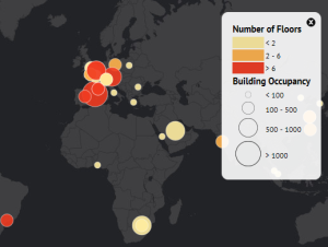
Thematic class-break markers show data themed by bucketed ranges.
Graduated class-break markers show data sized by bucketed ranges.
Thematic graduated markers can show multiple dimensions of data simultaneously.
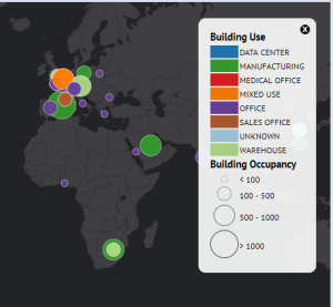
Thematic, class-break graduated markers show multi-dimensional data in bucketed ranges.
Thematic, unique-value proportional markers can simultaneously show both themed data, such as building use, and real-world proportional data, such as an evacuation radius.
Thematic, class-break proportional markers can simultaneously show bucketed data ranges and real-world sizes.
Maps on the Navigation (Home) Page
Add-in Managers may wish to review the Asset Management home page descriptor as an example of a map "bucket" added to the home page.
- Path: schema\ab-products\common\views\page-navigation\descriptors\ab-navigation-home-assets-level-4.xml
Using Enterprise Graphics and GIS
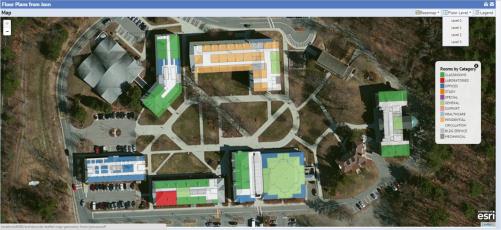
The new standard control can combine ARCHIBUS enterprise graphics published from AutoCAD or Revit with GIS content. This feature is useful for creating forms that must combine both the inside-building and outside-building view, as is the case for functions such as wayfinding. Using enterprise graphics is a useful alternative to publishing all interior elements to the GIS server, as this technique can use generic GIS Web Services and does not require you to stand up your own server for your own GIS features.
| Copyright © 1984-2015, ARCHIBUS, Inc. All rights reserved.
|